We are a team of technicians and engineers and test every scanner ourselves before recommending it. You receive a solution that works in your real workflow.
Personal project consultationWe assess your part, tolerances and process together.Fast support from AustriaDirect access to experienced users.
Workflow library includedLive demo or trial unit available
Leica Geosystems
ScanStation P30 / P40 / P50
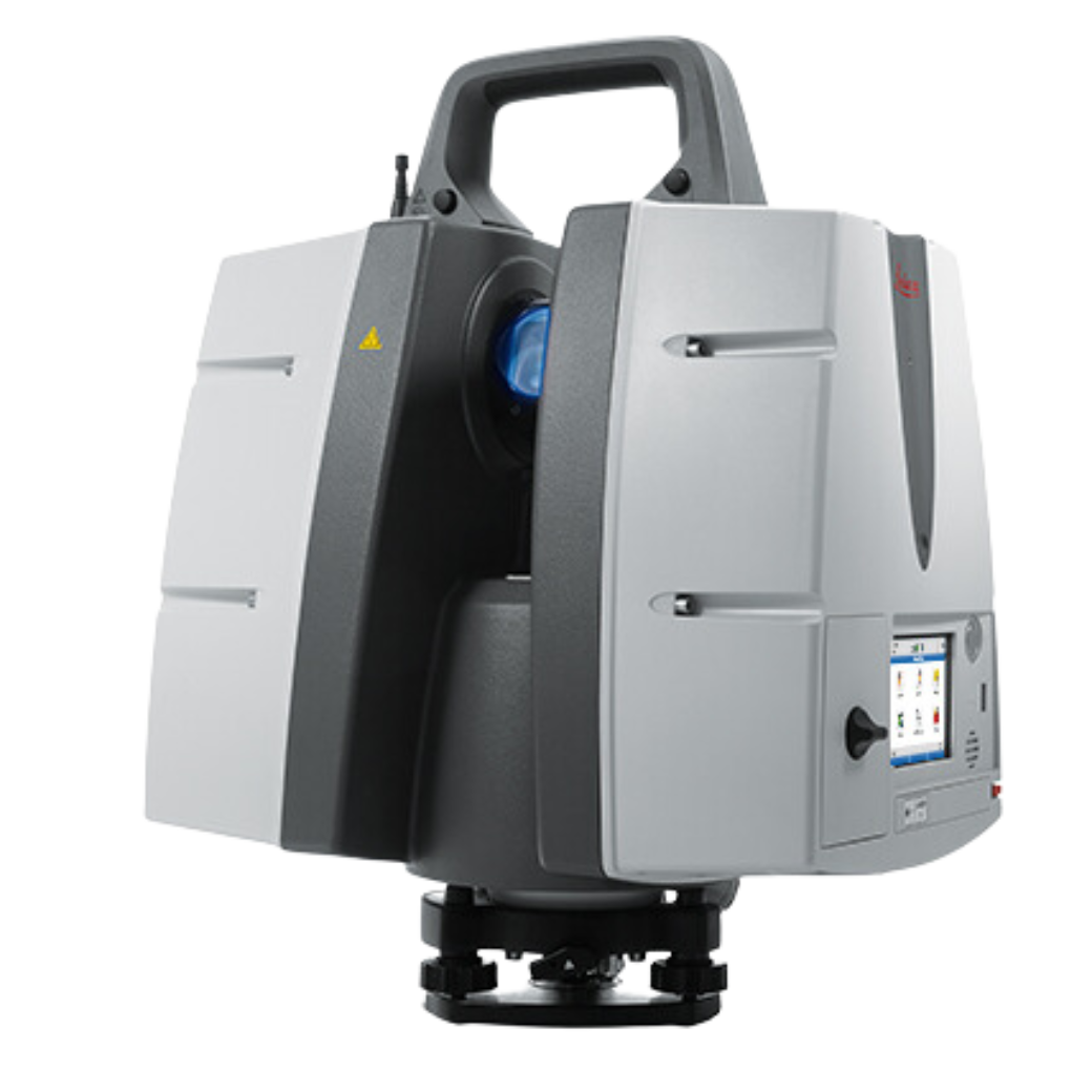
The Leica ScanStation P30, P40, and P50 capture high-precision 3D data at up to one million points per second with ranges up to over 1 kilometer.
LEICA-GEOSYSTEMS-SCANSTATION-P30-P40-P50SKU1VariantshardwareProduct type
01 / 04
Leica Geosystems ScanStation P30 / P40 / P50
The Leica ScanStation P30, P40, and P50 capture high-precision 3D data at up to one million points per second with ranges up to over 1 kilometer.
Price on request
excl. VAT · plus shipping
Price and availability are provided on request.
workflow library includedExpert consultation
All details
Product information
The Leica ScanStation P30, P40, and P50 are advanced terrestrial laser scanners designed by Leica Geosystems for precise, high-speed 3D data capture and HDR imaging. Tailored for demanding surveying, construction, and engineering applications, these models offer exceptional versatility and accuracy in capturing detailed point clouds over various ranges.
The P30 and P40 models provide reliable scanning at ranges up to 270 meters, making them ideal for medium-range projects requiring fast and precise data acquisition. In contrast, the P50 model extends this capability to over 1 kilometer, allowing users to scan inaccessible or large-scale sites without compromise.
Equipped with ultra-high-speed pulsed, dual-axis compensated lasers, these scanners capture up to one million points per second, ensuring detailed and rich data collection. Their compact design and robust build enable operation in harsh environmental conditions, supplemented by efficient power management with dual lithium-ion batteries.
Users benefit from survey-grade angular and range accuracy, full 360° horizontal and up to 290° vertical field of view, integrated 4-megapixel color imaging, and enhanced target acquisition features. The P50 specifically features waveform digitizing technology for superior long-range performance, suitable for extensive and complex scanning tasks.
These scanners integrate seamlessly with Leica's comprehensive software suite, facilitating efficient data processing and project management. They are the tool of choice for professionals needing reliable, long-range, and high-precision terrestrial laser scanning solutions.
Features
Survey-grade Accuracy
Achieves range accuracy of 1.2 mm + 10 ppm and angular accuracy of 8" for precise measurements
Integrated HDR Imaging
Features a 4-megapixel camera capturing high-quality color images for enhanced data visualization
Ultra-high-speed scanning
Captures up to 1 million points per second for rapid and detailed 3D data acquisition
Robust Design and Power
Compact, durable build with dual lithium-ion batteries supporting over 5.5 hours of operation
Variable Range Capabilities
P30/P40 models scan up to 270 m, while P50 extends range beyond 1 km for versatile application
Technical product details
SKULEICA-GEOSYSTEMS-SCANSTATION-P30-P40-P50
Measurement
AccuracyRange accuracy: 1.2 mm + 10 ppm; angular accuracy: 8"
RangeUp to 270 m (P30/P40), over 1 km (P50)
The Leica ScanStation P30, P40, and P50 are advanced terrestrial laser scanners designed by Leica Geosystems for precise, high-speed 3D data capture and HDR imaging. Tailored for demanding surveying, construction, and engineering applications, these models offer exceptional versatility and accuracy in capturing detailed point clouds over various ranges.
The P30 and P40 models provide reliable scanning at ranges up to 270 meters, making them ideal for medium-range projects requiring fast and precise data acquisition. In contrast, the P50 model extends this capability to over 1 kilometer, allowing users to scan inaccessible or large-scale sites without compromise.
Equipped with ultra-high-speed pulsed, dual-axis compensated lasers, these scanners capture up to one million points per second, ensuring detailed and rich data collection. Their compact design and robust build enable operation in harsh environmental conditions, supplemented by efficient power management with dual lithium-ion batteries.
Users benefit from survey-grade angular and range accuracy, full 360° horizontal and up to 290° vertical field of view, integrated 4-megapixel color imaging, and enhanced target acquisition features. The P50 specifically features waveform digitizing technology for superior long-range performance, suitable for extensive and complex scanning tasks.
These scanners integrate seamlessly with Leica's comprehensive software suite, facilitating efficient data processing and project management. They are the tool of choice for professionals needing reliable, long-range, and high-precision terrestrial laser scanning solutions.
Features
Survey-grade Accuracy
Achieves range accuracy of 1.2 mm + 10 ppm and angular accuracy of 8" for precise measurements
Integrated HDR Imaging
Features a 4-megapixel camera capturing high-quality color images for enhanced data visualization
Ultra-high-speed scanning
Captures up to 1 million points per second for rapid and detailed 3D data acquisition
Robust Design and Power
Compact, durable build with dual lithium-ion batteries supporting over 5.5 hours of operation
Variable Range Capabilities
P30/P40 models scan up to 270 m, while P50 extends range beyond 1 km for versatile application
Technical product details
SKULEICA-GEOSYSTEMS-SCANSTATION-P30-P40-P50
Measurement
AccuracyRange accuracy: 1.2 mm + 10 ppm; angular accuracy: 8"
RangeUp to 270 m (P30/P40), over 1 km (P50)
Fields of application
Where ScanStation P30 / P40 / P50 is used
Industries
Applications
Why Scankraft?
We test every scanner ourselves before selling it.
You receive more than a device—you receive a field-tested solution matched to your measurement task.